


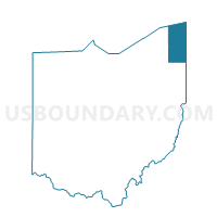
Trum 2 Voting District, Ashtabula County, Ohio
About
Outline

Summary
| Unique Area Identifier | 642678 |
| Name | Trum 2 Voting District |
| County | Ashtabula County |
| State | Ohio |
| Area (square miles) | 12.84 |
| Land Area (square miles) | 12.83 |
| Water Area (square miles) | 0.01 |
| % of Land Area | 99.94 |
| % of Water Area | 0.06 |
| Latitude of the Internal Point | 41.68525410 |
| Longtitude of the Internal Point | -80.93812810 |
Maps


Graphs
Select a template below for downloading or customizing gragh for Trum 2 Voting District, Ashtabula County, Ohio


Neighbors
Neighoring Voting District (by Name) Neighboring Voting District on the Map
- Aust. Twp 1 Voting District, Ashtabula County, OH
- Harp 2 Voting District, Ashtabula County, OH
- Harts 1 Voting District, Ashtabula County, OH
- Morgan Voting District, Ashtabula County, OH
- Rome Voting District, Ashtabula County, OH
- Trum 1 Voting District, Ashtabula County, OH
Top 10 Neighboring County Subdivision (by Population) Neighboring County Subdivision on the Map
- Harpersfield township, Ashtabula County, OH (2,695)
- Austinburg township, Ashtabula County, OH (2,197)
- Morgan township, Ashtabula County, OH (2,170)
- Rome township, Ashtabula County, OH (1,812)
- Hartsgrove township, Ashtabula County, OH (1,597)
- Trumbull township, Ashtabula County, OH (1,408)
Top 10 Neighboring Unified School District (by Population) Neighboring Unified School District on the Map
- Geneva Area City School District, OH (16,943)
- Jefferson Area Local School District, OH (11,576)
- Grand Valley Local School District, OH (9,531)